Bousso night lights from space
Night Light of Bousso (Chari-Baguirmi) from space (Chad) Src. Average luminocity for 10x10km area is 0.5062% and for 50x50km: 2.5068%.
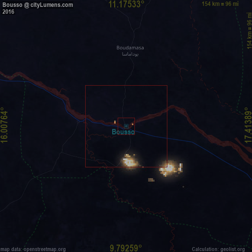
Analysis of Bousso night lights 2016
Square area 10x10 km:
 0%
0%90-99
0%80-89
0%70-79
0%60-69
0.83%50-59
0%40-49
0%30-39
0%20-29
0%10-19
0%0-9
99.17%Square area 50x50 km:
0.08%90-99
0.57%80-89
0.37%70-79
0.16%60-69
0.29%50-59
0.56%40-49
0.35%30-39
0.53%20-29
0.65%10-19
1.88%0-9
94.57%Clear (daylight) street map image can be seen on geolist.org.
Map coordinates:
11° 10' 31.2" North, 16° 0' 27.5" East
10° 29' 5" North, 16° 42' 38.7" East
9° 47' 33.3" North, 17° 24' 50" East
Some cities around Bousso sort by population:
• Bongor
148.1 km =92 mi,  261°
261°
• Laï
129 km =80.2 mi,  200°
200°
• Béré
143.1 km =88.9 mi,  205°
205°
• Ngama
152.7 km =94.9 mi,  19°
19°
• Guelendeng
135.6 km =84.3 mi,  290°
290°
• Goundi
143.9 km =89.4 mi,  150°
150°
• Melfi
148.3 km =92.1 mi,  64°
64°
• Massenya
118 km =73.3 mi,  330°
330°
2434584 (p: 13,555)
Sources (retrieved 2019-11-25):
» Earth at Night: Flat Maps 2012, 2016