Inkhil night lights from space
Night Light of Inkhil (Daraa) from space (Syria) Src. Average luminocity for 10x10km area is 0.0018% and for 50x50km: 0.9665%.
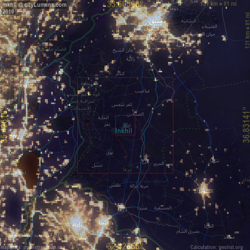

Analysis of Inkhil night lights 2016
Square area 10x10 km:
 0%
0%90-99
0%80-89
0%70-79
0%60-69
0%50-59
0%40-49
0%30-39
0%20-29
0%10-19
0%0-9
100%Square area 50x50 km:
0%90-99
0%80-89
0.05%70-79
0.15%60-69
0.12%50-59
0.17%40-49
0.41%30-39
0.47%20-29
0.52%10-19
0.27%0-9
97.84%Clear (daylight) street map image can be seen on geolist.org.
Map coordinates:
33° 36' 20.4" North, 35° 25' 30.6" East
33° 1' 5.1" North, 36° 7' 41.8" East
32° 25' 35.6" North, 36° 49' 53.1" East
Some cities around Inkhil sort by population:
• Al Qunayţirah
30.7 km =19.1 mi,  292°
292°
• Ţafas
31.8 km =19.8 mi,  190°
190°
• Jāsim
7 km =4.3 mi,  245°
245°
• Ash Shaykh Miskīn
21.2 km =13.2 mi,  172°
172°
• Aş Şanamayn
7.9 km =4.9 mi,  40°
40°
• Al Ḩarāk
34.4 km =21.4 mi,  150°
150°
• Al Kiswah
39.3 km =24.4 mi,  15°
15°
• Izra‘
20.2 km =12.6 mi,  144°
144°
169375 (p: 29,076)
Sources (retrieved 2019-11-25):
» Earth at Night: Flat Maps 2012, 2016