Ad Duraykīsh night lights from space
Night Light of Ad Duraykīsh (Tartus) from space (Syria) Src. Average luminocity for 10x10km area is 1.4505% and for 50x50km: 5.187%.
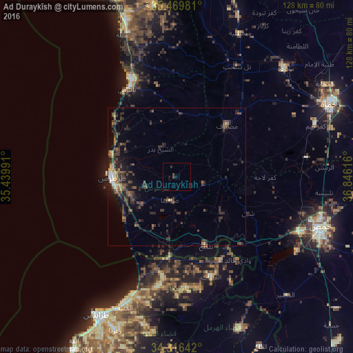
Analysis of Ad Duraykīsh night lights 2016
Square area 10x10 km:
 0%
0%90-99
0%80-89
0%70-79
0%60-69
0%50-59
0%40-49
1.47%30-39
0.73%20-29
0.37%10-19
1.83%0-9
95.6%Square area 50x50 km:
0.14%90-99
0.22%80-89
0.41%70-79
0.39%60-69
0.74%50-59
0.91%40-49
1.79%30-39
2%20-29
2.64%10-19
3.4%0-9
87.36%Clear (daylight) street map image can be seen on geolist.org.
Map coordinates:
35° 28' 11.3" North, 35° 26' 23.7" East
34° 53' 42.5" North, 36° 8' 34.9" East
34° 18' 59.1" North, 36° 50' 46.2" East
Some cities around Ad Duraykīsh sort by population:
• Tartouss
23.4 km =14.5 mi,  268°
268°
• Bāniyās
36.5 km =22.7 mi,  330°
330°
• Maşyāf
26.1 km =16.2 mi,  43°
43°
• Tallkalakh
27.4 km =17 mi,  157°
157°
• Satita
8.6 km =5.3 mi,  195°
195°
• Kafr Lāhā
32.2 km =20 mi,  90°
90°
• Al Ghanţū
51.1 km =31.8 mi,  99°
99°
• Halba, LB
39.6 km =24.6 mi,  188°
188°
170572 (p: 11,918)
Sources (retrieved 2019-11-25):
» Earth at Night: Flat Maps 2012, 2016