Šurany night lights from space
Night Light of Šurany (Nitriansky kraj) from space (Slovakia) Src. Average luminocity for 10x10km area is 3.2902% and for 50x50km: 3.453%.
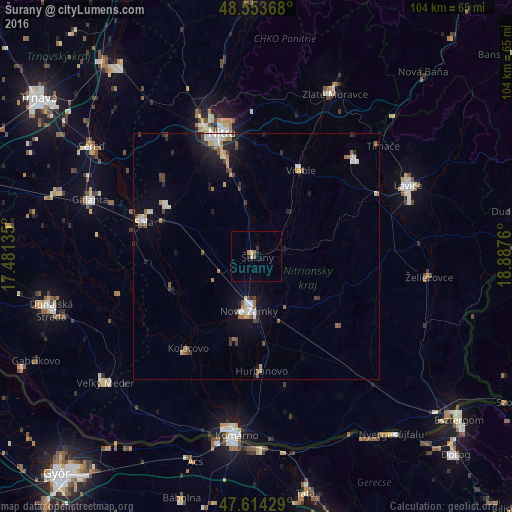
Analysis of Šurany night lights 2016
Square area 10x10 km:
 0%
0%90-99
0%80-89
1.19%70-79
0.6%60-69
0%50-59
0.74%40-49
0.45%30-39
0.6%20-29
0.6%10-19
0.6%0-9
95.24%Square area 50x50 km:
0.48%90-99
0.5%80-89
0.4%70-79
0.29%60-69
0.45%50-59
0.43%40-49
0.5%30-39
0.41%20-29
0.62%10-19
2.11%0-9
93.8%Clear (daylight) street map image can be seen on geolist.org.
Map coordinates:
48° 33' 13.2" North, 17° 28' 52.9" East
48° 5' 10.1" North, 18° 11' 4.1" East
47° 36' 51.4" North, 18° 53' 15.4" East
Some cities around Šurany sort by population:
• Nitra
25.7 km =16 mi,  343°
343°
• Nové Zámky
11.3 km =7 mi,  188°
188°
• Levice
34.5 km =21.4 mi,  65°
65°
• Šaľa
23.7 km =14.7 mi,  287°
287°
• Kolárovo
23.5 km =14.6 mi,  219°
219°
• Vráble
19.8 km =12.3 mi,  27°
27°
• Hurbanovo
24.1 km =15 mi,  178°
178°
• Želiezovce
35.1 km =21.8 mi,  96°
96°
3057339 (p: 10,491)
Sources (retrieved 2019-11-25):
» Earth at Night: Flat Maps 2012, 2016