Stupava night lights from space
Night Light of Stupava (Bratislavský kraj) from space (Slovakia) Src. Average luminocity for 10x10km area is 19.4792% and for 50x50km: 14.0888%.
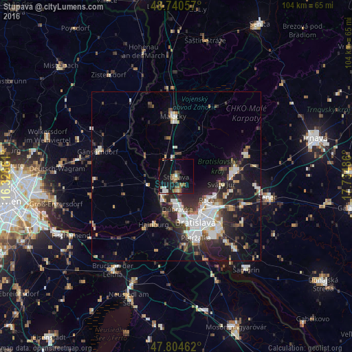
Analysis of Stupava night lights 2016
Square area 10x10 km:
 2.23%
2.23%90-99
2.68%80-89
0.15%70-79
1.49%60-69
5.06%50-59
4.46%40-49
1.19%30-39
0.45%20-29
5.21%10-19
24.7%0-9
52.38%Square area 50x50 km:
3.05%90-99
3%80-89
0.7%70-79
0.99%60-69
1.37%50-59
1.52%40-49
1.62%30-39
2.21%20-29
4.94%10-19
9.58%0-9
71.03%Clear (daylight) street map image can be seen on geolist.org.
Map coordinates:
48° 44' 26.1" North, 16° 19' 43" East
48° 16' 29.1" North, 17° 1' 54.2" East
47° 48' 16.6" North, 17° 44' 5.5" East
Some cities around Stupava sort by population:
• Bratislava
15.1 km =9.4 mi,  158°
158°
• Pezinok
17.5 km =10.9 mi,  84°
84°
• Malacky
17.9 km =11.1 mi,  357°
357°
• Gänserndorf, AT
24.1 km =15 mi,  287°
287°
• Modra
21.4 km =13.3 mi,  72°
72°
• Hainburg an der Donau, AT
15.7 km =9.8 mi,  204°
204°
• Ivanka pri Dunaji
19.2 km =11.9 mi,  120°
120°
• Bratislava - Vajnory
15.1 km =9.4 mi, 120°
3057384 (p: 8,063)
Sources (retrieved 2019-11-25):
» Earth at Night: Flat Maps 2012, 2016