Gänserndorf night lights from space
Night Light of Gänserndorf (Lower Austria) from space (Austria) Src. Average luminocity for 10x10km area is 11.1747% and for 50x50km: 14.7345%.
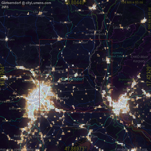
Analysis of Gänserndorf night lights 2016
Square area 10x10 km:
 0.99%
0.99%90-99
1.85%80-89
0.57%70-79
0.57%60-69
0.14%50-59
1.99%40-49
1.14%30-39
3.55%20-29
2.84%10-19
3.69%0-9
82.67%Square area 50x50 km:
3.11%90-99
3.46%80-89
1.33%70-79
1.33%60-69
1.8%50-59
1.7%40-49
1.25%30-39
2.05%20-29
3.86%10-19
5.02%0-9
75.09%Clear (daylight) street map image can be seen on geolist.org.
Map coordinates:
48° 48' 16.2" North, 16° 1' 1.3" East
48° 20' 21.3" North, 16° 43' 12.6" East
47° 52' 11" North, 17° 25' 23.8" East
Some cities around Gänserndorf sort by population:
• Donaustadt
22.6 km =14 mi,  238°
238°
• Floridsdorf
25.7 km =16 mi,  247°
247°
• Malacky, SK
24.7 km =15.3 mi,  64°
64°
• Strasshof an der Nordbahn
4.7 km =2.9 mi, 237°
• Gerasdorf bei Wien
19.3 km =12 mi,  255°
255°
• Deutsch-Wagram
12.2 km =7.6 mi, 248°
• Stupava, SK
24.1 km =15 mi,  107°
107°
• Groß-Enzersdorf
19.7 km =12.2 mi,  219°
219°
2778877 (p: 11,404)
Sources (retrieved 2019-11-25):
» Earth at Night: Flat Maps 2012, 2016