Bratislava - Vajnory night lights from space
Night Light of Bratislava - Vajnory (Bratislavský kraj) from space (Slovakia) Src. Average luminocity for 10x10km area is 54.5536% and for 50x50km: 14.7399%.
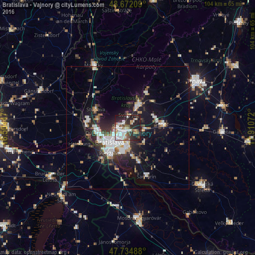
Analysis of Bratislava - Vajnory night lights 2016
Square area 10x10 km:
 14.58%
90-99
16.96%80-89
1.64%70-79
3.57%60-69
4.76%50-59
6.55%40-49
4.76%30-39
6.55%20-29
25.89%10-19
14.73%0-9
0%Square area 50x50 km:
3.14%90-99
3.02%80-89
0.78%70-79
0.95%60-69
1.52%50-59
1.6%40-49
1.63%30-39
2.43%20-29
4.93%10-19
10.75%0-9
69.23%Clear (daylight) street map image can be seen on geolist.org.
Map coordinates:
48° 40' 19.5" North, 16° 30' 16.1" East
48° 12' 20.3" North, 17° 12' 27.3" East
47° 44' 5.6" North, 17° 54' 38.6" East
Some cities around Bratislava - Vajnory sort by population:
• Pezinok
10.3 km =6.4 mi,  25°
25°
• Malacky
29.1 km =18.1 mi,  331°
331°
• Senec
14.4 km =8.9 mi,  83°
83°
• Šamorín
20.9 km =13 mi,  158°
158°
• Modra
16.1 km =10 mi, 27°
• Stupava
15.1 km =9.4 mi,  300°
300°
• Hainburg an der Donau, AT
20.6 km =12.8 mi,  251°
251°
• Ivanka pri Dunaji
4.1 km =2.5 mi,  120°
120°
3060280 (p: 5,484)
Sources (retrieved 2019-11-25):
» Earth at Night: Flat Maps 2012, 2016