Modra night lights from space
Night Light of Modra (Bratislavský kraj) from space (Slovakia) Src. Average luminocity for 10x10km area is 16.7713% and for 50x50km: 14.3212%.
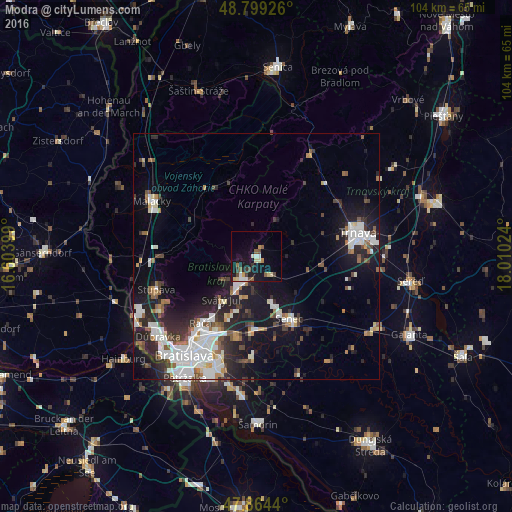
Analysis of Modra night lights 2016
Square area 10x10 km:
 1.14%
1.14%90-99
2.84%80-89
3.13%70-79
1.56%60-69
1.28%50-59
2.84%40-49
2.56%30-39
1.99%20-29
1.14%10-19
18.32%0-9
63.21%Square area 50x50 km:
3.38%90-99
3.18%80-89
0.77%70-79
0.81%60-69
1.43%50-59
1.64%40-49
1.45%30-39
1.99%20-29
4.45%10-19
10.03%0-9
70.87%Clear (daylight) street map image can be seen on geolist.org.
Map coordinates:
48° 47' 57.3" North, 16° 36' 14.4" East
48° 20' 2.3" North, 17° 18' 25.6" East
47° 51' 51.8" North, 18° 0' 36.9" East
Some cities around Modra sort by population:
• Bratislava
25.4 km =15.8 mi,  215°
215°
• Trnava
21.3 km =13.2 mi,  76°
76°
• Pezinok
5.7 km =3.5 mi,  211°
211°
• Malacky
23.9 km =14.9 mi,  298°
298°
• Senec
14.5 km =9 mi,  151°
151°
• Stupava
21.4 km =13.3 mi,  252°
252°
• Ivanka pri Dunaji
16.8 km =10.4 mi,  193°
193°
• Bratislava - Vajnory
16.1 km =10 mi, 207°
3058663 (p: 8,536)
Sources (retrieved 2019-11-25):
» Earth at Night: Flat Maps 2012, 2016