Žarnovica night lights from space
Night Light of Žarnovica (Banskobystrický kraj) from space (Slovakia) Src. Average luminocity for 10x10km area is 1.4219% and for 50x50km: 1.2802%.
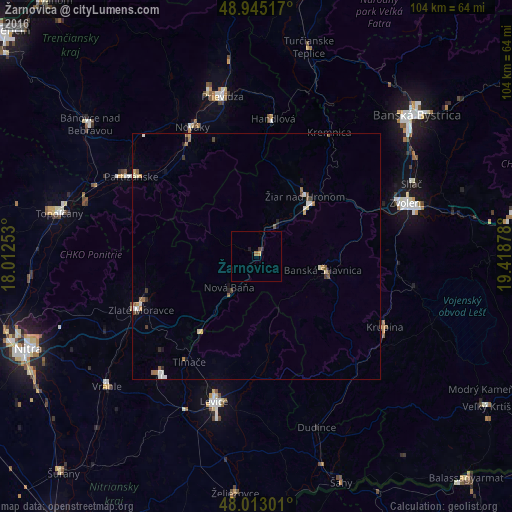
Analysis of Žarnovica night lights 2016
Square area 10x10 km:
 0%
0%90-99
0%80-89
0%70-79
0.57%60-69
0.43%50-59
0.14%40-49
0.28%30-39
0.28%20-29
0.57%10-19
0.57%0-9
97.16%Square area 50x50 km:
0.14%90-99
0.19%80-89
0.18%70-79
0.14%60-69
0.24%50-59
0.21%40-49
0.18%30-39
0.15%20-29
0.17%10-19
0.19%0-9
98.22%Clear (daylight) street map image can be seen on geolist.org.
Map coordinates:
48° 56' 42.6" North, 18° 0' 45.1" East
48° 28' 52.4" North, 18° 42' 56.3" East
48° 0' 46.8" North, 19° 25' 7.6" East
Some cities around Žarnovica sort by population:
• Partizánske
29.4 km =18.3 mi,  303°
303°
• Žiar nad Hronom
15.8 km =9.8 mi,  38°
38°
• Handlová
27.6 km =17.1 mi,  6°
6°
• Zlaté Moravce
25.6 km =15.9 mi,  245°
245°
• Banská Štiavnica
14.8 km =9.2 mi,  104°
104°
• Krupina
29.3 km =18.2 mi,  118°
118°
• Nová Baňa
8.5 km =5.3 mi,  220°
220°
• Kremnica
29 km =18 mi,  30°
30°
3056589 (p: 6,596)
Sources (retrieved 2019-11-25):
» Earth at Night: Flat Maps 2012, 2016