Zgornje Gorje night lights from space
Night Light of Zgornje Gorje (Gorje) from space (Slovenia) Src. Average luminocity for 10x10km area is 4.8467% and for 50x50km: 3.1567%.
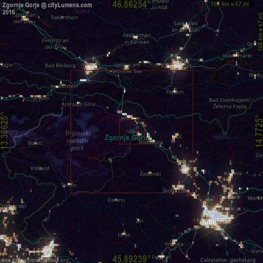
Analysis of Zgornje Gorje night lights 2016
Square area 10x10 km:
 0%
0%90-99
0.45%80-89
0.74%70-79
0%60-69
0%50-59
0.45%40-49
1.34%30-39
1.79%20-29
1.79%10-19
1.19%0-9
92.26%Square area 50x50 km:
0.29%90-99
0.42%80-89
0.3%70-79
0.34%60-69
0.35%50-59
0.35%40-49
0.54%30-39
0.48%20-29
0.45%10-19
3.13%0-9
93.34%Clear (daylight) street map image can be seen on geolist.org.
Map coordinates:
46° 51' 45.1" North, 13° 21' 58.5" East
46° 22' 46.6" North, 14° 4' 9.7" East
45° 53' 32.6" North, 14° 46' 21" East
Some cities around Zgornje Gorje sort by population:
• Jesenice
5.7 km =3.5 mi,  358°
358°
• Radovljica
9 km =5.6 mi,  115°
115°
• Bled
3.6 km =2.2 mi,  108°
108°
• Tržič
18.6 km =11.6 mi,  95°
95°
• Železniki
18.9 km =11.7 mi,  155°
155°
• Bohinjska Bistrica
14.9 km =9.3 mi,  216°
216°
• Naklo
22.4 km =13.9 mi, 121°
• Žirovnica
6.1 km =3.8 mi,  62°
62°
3186514 (p: 500)
Sources (retrieved 2019-11-25):
» Earth at Night: Flat Maps 2012, 2016