Polzela night lights from space
Night Light of Polzela from space (Slovenia) Src. Average luminocity for 10x10km area is 2.8973% and for 50x50km: 3.454%.
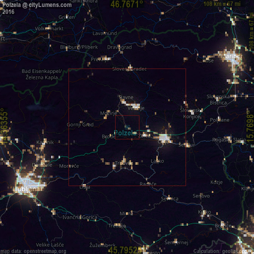
Analysis of Polzela night lights 2016
Square area 10x10 km:
100  0%
0%
90-99 0%
80-89 0%
70-79 0%
60-69 0.74%
50-59 1.64%
40-49 0.3%
30-39 1.19%
20-29 0%
10-19 0.3%
0-9 95.83%
0%90-99
0%80-89
0%70-79
0%60-69
0.74%50-59
1.64%40-49
0.3%30-39
1.19%20-29
0%10-19
0.3%0-9
95.83%Square area 50x50 km:
100 0.38%
90-99 0.55%
80-89 0.28%
70-79 0.29%
60-69 0.35%
50-59 0.58%
40-49 0.59%
30-39 0.53%
20-29 0.56%
10-19 1.91%
0-9 93.99%
0.38%90-99
0.55%80-89
0.28%70-79
0.29%60-69
0.35%50-59
0.58%40-49
0.59%30-39
0.53%20-29
0.56%10-19
1.91%0-9
93.99%Clear (daylight) street map image can be seen on geolist.org.
Map coordinates:
46° 46' 1.6" North, 14° 21' 48.8" East
46° 16' 60" North, 15° 4' 0" East
45° 47' 42.9" North, 15° 46' 11.3" East
Some cities around Polzela sort by population:
• Velenje
9.1 km =5.7 mi,  21°
21°
• Žalec
8.3 km =5.2 mi,  115°
115°
• Prebold
5.5 km =3.4 mi,  158°
158°
• Nazarje
10 km =6.2 mi,  292°
292°
• Vransko
9.9 km =6.2 mi,  243°
243°
• Šmartno ob Paki
6.1 km =3.8 mi,  335°
335°
• Tabor
6.4 km =4 mi,  215°
215°
• Braslovče
2.2 km =1.4 mi, 288°
3192762 (p: 2,380)
Sources (retrieved 2019-11-25):
» Earth at Night: Flat Maps 2012, 2016