Rače night lights from space
Night Light of Rače (Rače-Fram) from space (Slovenia) Src. Average luminocity for 10x10km area is 15.7827% and for 50x50km: 6.5083%.
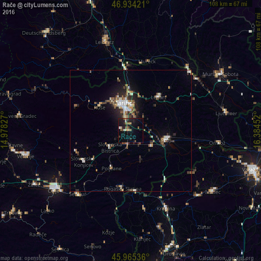
Analysis of Rače night lights 2016
Square area 10x10 km:
 0.74%
0.74%90-99
1.79%80-89
1.79%70-79
0.89%60-69
1.49%50-59
3.72%40-49
1.49%30-39
1.04%20-29
5.36%10-19
21.88%0-9
59.82%Square area 50x50 km:
0.78%90-99
1.1%80-89
0.46%70-79
0.47%60-69
0.83%50-59
1.02%40-49
1.16%30-39
1.05%20-29
2.07%10-19
3.31%0-9
87.76%Clear (daylight) street map image can be seen on geolist.org.
Map coordinates:
46° 56' 3.2" North, 14° 58' 41.8" East
46° 27' 7" North, 15° 40' 53" East
45° 57' 55.3" North, 16° 23' 4.3" East
Some cities around Rače sort by population:
• Maribor
11.7 km =7.3 mi,  346°
346°
• Slovenska Bistrica
10.5 km =6.5 mi,  231°
231°
• Miklavž na Dravskem Polju
6.1 km =3.8 mi,  11°
11°
• Spodnje Hoče
5.9 km =3.7 mi,  335°
335°
• Spodnji Duplek
7.5 km =4.7 mi,  40°
40°
• Kidričevo
10 km =6.2 mi,  122°
122°
• Starše
6.8 km =4.2 mi,  76°
76°
• Majšperk
11.8 km =7.3 mi,  160°
160°
3192165 (p: 2,529)
Sources (retrieved 2019-11-25):
» Earth at Night: Flat Maps 2012, 2016