Kidričevo night lights from space
Night Light of Kidričevo from space (Slovenia) Src. Average luminocity for 10x10km area is 10.0685% and for 50x50km: 6.5759%.
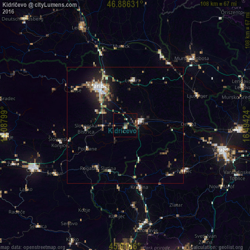
Analysis of Kidričevo night lights 2016
Square area 10x10 km:
 0.6%
0.6%90-99
0.6%80-89
0%70-79
1.04%60-69
1.64%50-59
2.98%40-49
3.27%30-39
1.49%20-29
1.79%10-19
1.04%0-9
85.57%Square area 50x50 km:
0.74%90-99
1.04%80-89
0.46%70-79
0.52%60-69
0.89%50-59
1.02%40-49
1.24%30-39
1.13%20-29
2.18%10-19
3.42%0-9
87.37%Clear (daylight) street map image can be seen on geolist.org.
Map coordinates:
46° 53' 10.7" North, 15° 5' 16.8" East
46° 24' 13" North, 15° 47' 28" East
45° 54' 59.8" North, 16° 29' 39.3" East
Some cities around Kidričevo sort by population:
• Ptuj
6.3 km =3.9 mi,  73°
73°
• Rače
10 km =6.2 mi,  302°
302°
• Starše
7.2 km =4.5 mi,  345°
345°
• Majšperk
7.3 km =4.5 mi,  217°
217°
• Videm pri Ptuju
9.7 km =6 mi,  113°
113°
• Markovci
10.6 km =6.6 mi,  94°
94°
• Podlehnik
10.2 km =6.3 mi,  138°
138°
• Spodnja Hajdina
4.3 km =2.7 mi,  82°
82°
3198165 (p: 1,253)
Sources (retrieved 2019-11-25):
» Earth at Night: Flat Maps 2012, 2016