Horjul night lights from space
Night Light of Horjul from space (Slovenia) Src. Average luminocity for 10x10km area is 2.1136% and for 50x50km: 8.1908%.
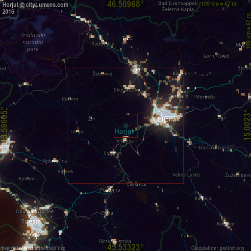
Analysis of Horjul night lights 2016
Square area 10x10 km:
 0%
0%90-99
0.43%80-89
0.14%70-79
0%60-69
0.28%50-59
0.28%40-49
0.57%30-39
0%20-29
1.42%10-19
0.85%0-9
96.02%Square area 50x50 km:
1.35%90-99
1.48%80-89
0.75%70-79
0.72%60-69
0.83%50-59
1.04%40-49
1.19%30-39
1.23%20-29
2.62%10-19
6.61%0-9
82.19%Clear (daylight) street map image can be seen on geolist.org.
Map coordinates:
46° 30' 34.8" North, 13° 35' 45.8" East
46° 1' 25" North, 14° 17' 57" East
45° 31' 59.6" North, 15° 0' 8.3" East
Some cities around Horjul sort by population:
• Logatec
13.4 km =8.3 mi,  205°
205°
• Vrhnika
6.7 km =4.2 mi,  182°
182°
• Žiri
15 km =9.3 mi,  277°
277°
• Brezovica pri Ljubljani
7.9 km =4.9 mi,  82°
82°
• Borovnica
13 km =8.1 mi,  157°
157°
• Log pri Brezovici
5.3 km =3.3 mi,  98°
98°
• Gorenja Vas
14.9 km =9.3 mi,  308°
308°
• Dobrova
7.6 km =4.7 mi,  70°
70°
3199347 (p: 1,329)
Sources (retrieved 2019-11-25):
» Earth at Night: Flat Maps 2012, 2016