Dobrova night lights from space
Night Light of Dobrova (Dobrova-Horjul-Polhov Gradec) from space (Slovenia) Src. Average luminocity for 10x10km area is 12.6889% and for 50x50km: 8.8483%.
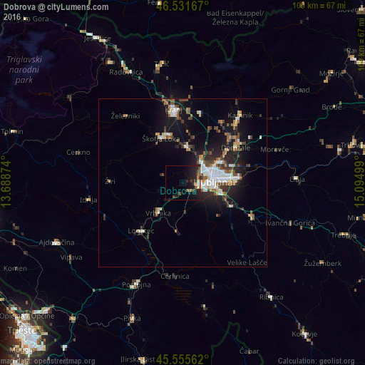
Analysis of Dobrova night lights 2016
Square area 10x10 km:
 0.71%
0.71%90-99
1.42%80-89
1.28%70-79
1.14%60-69
1.14%50-59
1.7%40-49
2.27%30-39
2.13%20-29
8.24%10-19
16.19%0-9
63.78%Square area 50x50 km:
1.38%90-99
1.55%80-89
0.75%70-79
0.71%60-69
0.98%50-59
1.15%40-49
1.5%30-39
1.25%20-29
2.62%10-19
7.27%0-9
80.83%Clear (daylight) street map image can be seen on geolist.org.
Map coordinates:
46° 31' 54" North, 13° 41' 19.5" East
46° 2' 44.9" North, 14° 23' 30.7" East
45° 33' 20.2" North, 15° 5' 42" East
Some cities around Dobrova sort by population:
• Ljubljana
8.8 km =5.5 mi,  86°
86°
• Vrhnika
11.8 km =7.3 mi,  219°
219°
• Medvode
10.8 km =6.7 mi,  7°
7°
• Brezovica pri Ljubljani
1.5 km =0.9 mi,  155°
155°
• Ig
14.2 km =8.8 mi,  131°
131°
• Borovnica
14.6 km =9.1 mi,  188°
188°
• Log pri Brezovici
3.8 km =2.4 mi,  210°
210°
• Horjul
7.6 km =4.7 mi,  250°
250°
3201901 (p: 943)
Sources (retrieved 2019-11-25):
» Earth at Night: Flat Maps 2012, 2016