Črnomelj night lights from space
Night Light of Črnomelj from space (Slovenia) Src. Average luminocity for 10x10km area is 5.8273% and for 50x50km: 1.415%.
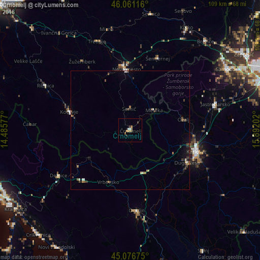
Analysis of Črnomelj night lights 2016
Square area 10x10 km:
 0.61%
0.61%90-99
0.61%80-89
0%70-79
1.97%60-69
1.36%50-59
0.91%40-49
0.45%30-39
1.06%20-29
0.3%10-19
0.61%0-9
92.12%Square area 50x50 km:
0.07%90-99
0.17%80-89
0.1%70-79
0.1%60-69
0.31%50-59
0.21%40-49
0.35%30-39
0.32%20-29
0.29%10-19
0.61%0-9
97.46%Clear (daylight) street map image can be seen on geolist.org.
Map coordinates:
46° 3' 40.2" North, 14° 29' 8.8" East
45° 34' 16" North, 15° 11' 20" East
45° 4' 36.3" North, 15° 53' 31.3" East
Some cities around Črnomelj sort by population:
• Karlovac, HR
29.5 km =18.3 mi,  107°
107°
• Novo Mesto
25.9 km =16.1 mi,  356°
356°
• Kočevje
26.6 km =16.5 mi,  287°
287°
• Metlika
12.9 km =8 mi,  49°
49°
• Semič
8.4 km =5.2 mi, 356°
• Straža
24.9 km =15.5 mi,  338°
338°
• Dolenjske Toplice
23 km =14.3 mi,  333°
333°
• Kostel
22.8 km =14.2 mi,  252°
252°
3202333 (p: 5,776)
Sources (retrieved 2019-11-25):
» Earth at Night: Flat Maps 2012, 2016