Kostel night lights from space
Night Light of Kostel from space (Slovenia) Src. Average luminocity for 10x10km area is 0.2159% and for 50x50km: 1.1932%.
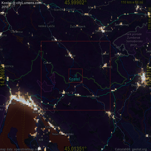
Analysis of Kostel night lights 2016
Square area 10x10 km:
 0%
0%90-99
0%80-89
0%70-79
0%60-69
0%50-59
0%40-49
0%30-39
0%20-29
0.48%10-19
0.48%0-9
99.05%Square area 50x50 km:
0.08%90-99
0.18%80-89
0.11%70-79
0.13%60-69
0.23%50-59
0.18%40-49
0.22%30-39
0.23%20-29
0.26%10-19
0.23%0-9
98.14%Clear (daylight) street map image can be seen on geolist.org.
Map coordinates:
45° 59' 56.5" North, 14° 12' 24.9" East
45° 30' 30.3" North, 14° 54' 36.2" East
45° 0' 48.6" North, 15° 36' 47.4" East
Some cities around Kostel sort by population:
• Kočevje
15.4 km =9.6 mi,  346°
346°
• Črnomelj
22.8 km =14.2 mi,  72°
72°
• Ribnica
29.3 km =18.2 mi,  330°
330°
• Semič
26.1 km =16.2 mi,  54°
54°
• Straža
32.7 km =20.3 mi,  22°
22°
• Dolenjske Toplice
29.9 km =18.6 mi, 22°
• Hrib-Loški Potok
31.7 km =19.7 mi,  314°
314°
• Osilnica
16.7 km =10.4 mi,  277°
277°
8358613 (p: 12)
Sources (retrieved 2019-11-25):
» Earth at Night: Flat Maps 2012, 2016