Kočevje night lights from space
Night Light of Kočevje from space (Slovenia) Src. Average luminocity for 10x10km area is 6.35% and for 50x50km: 1.115%.
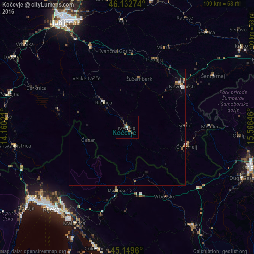
Analysis of Kočevje night lights 2016
Square area 10x10 km:
 0.91%
0.91%90-99
0.91%80-89
0%70-79
0.76%60-69
0.45%50-59
1.21%40-49
2.27%30-39
1.36%20-29
1.82%10-19
0.61%0-9
89.7%Square area 50x50 km:
0.15%90-99
0.17%80-89
0.05%70-79
0.13%60-69
0.15%50-59
0.14%40-49
0.23%30-39
0.18%20-29
0.26%10-19
0.32%0-9
98.22%Clear (daylight) street map image can be seen on geolist.org.
Map coordinates:
46° 7' 57.9" North, 14° 9' 36.8" East
45° 38' 36" North, 14° 51' 48" East
45° 8' 58.6" North, 15° 33' 59.3" East
Some cities around Kočevje sort by population:
• Ribnica
15 km =9.3 mi,  315°
315°
• Straža
22.3 km =13.9 mi,  46°
46°
• Žužemberk
21.8 km =13.5 mi,  13°
13°
• Sodražica
22 km =13.7 mi,  306°
306°
• Dolenjske Toplice
19.7 km =12.2 mi, 50°
• Hrib-Loški Potok
20.4 km =12.7 mi,  290°
290°
• Osilnica
18.1 km =11.2 mi,  225°
225°
• Kostel
15.4 km =9.6 mi,  166°
166°
3197943 (p: 8,672)
Sources (retrieved 2019-11-25):
» Earth at Night: Flat Maps 2012, 2016