Straža night lights from space
Night Light of Straža from space (Slovenia) Src. Average luminocity for 10x10km area is 2.4254% and for 50x50km: 1.7219%.
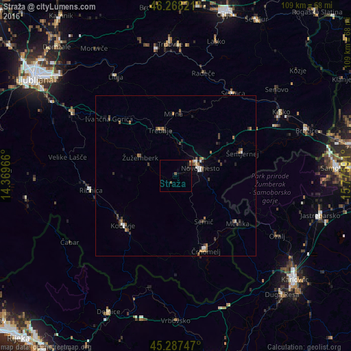
Analysis of Straža night lights 2016
Square area 10x10 km:
 0%
0%90-99
0%80-89
0%70-79
0.63%60-69
0%50-59
1.27%40-49
0.63%30-39
0%20-29
0.63%10-19
0.63%0-9
96.19%Square area 50x50 km:
0.16%90-99
0.2%80-89
0.02%70-79
0.28%60-69
0.34%50-59
0.27%40-49
0.45%30-39
0.3%20-29
0.34%10-19
0.42%0-9
97.2%Clear (daylight) street map image can be seen on geolist.org.
Map coordinates:
46° 16' 5.6" North, 14° 22' 10.8" East
45° 46' 48" North, 15° 4' 22" East
45° 17' 14.9" North, 15° 46' 33.3" East
Some cities around Straža sort by population:
• Novo Mesto
7.9 km =4.9 mi,  70°
70°
• Trebnje
14.4 km =8.9 mi,  344°
344°
• Semič
17.1 km =10.6 mi,  150°
150°
• Žužemberk
12.6 km =7.8 mi,  298°
298°
• Mirna Peč
9 km =5.6 mi,  5°
5°
• Dolenjske Toplice
2.8 km =1.7 mi,  202°
202°
• Mokronog
17.9 km =11.1 mi,  17°
17°
• Šmarjeta
17.9 km =11.1 mi,  50°
50°
3200385 (p: 1,996)
Sources (retrieved 2019-11-25):
» Earth at Night: Flat Maps 2012, 2016