Storvreta night lights from space
Night Light of Storvreta (Uppsala) from space (Sweden) Src. Average luminocity for 10x10km area is 7.9383% and for 50x50km: 4.7478%.
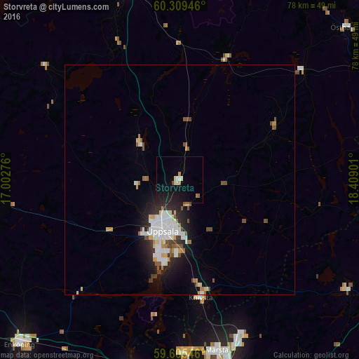
Analysis of Storvreta night lights 2016
Square area 10x10 km:
 0.22%
0.22%90-99
1.62%80-89
0.76%70-79
0.87%60-69
0.43%50-59
0.76%40-49
0.11%30-39
0%20-29
1.08%10-19
14.83%0-9
79.33%Square area 50x50 km:
0.93%90-99
1.21%80-89
0.47%70-79
0.37%60-69
0.37%50-59
0.46%40-49
0.63%30-39
0.32%20-29
1.34%10-19
2.63%0-9
91.28%Clear (daylight) street map image can be seen on geolist.org.
Map coordinates:
60° 18' 34.1" North, 17° 0' 9.9" East
59° 57' 33.6" North, 17° 42' 21.2" East
59° 36' 19.7" North, 18° 24' 32.4" East
Some cities around Storvreta sort by population:
• Uppsala
11.8 km =7.3 mi,  198°
198°
• Märsta
38.5 km =23.9 mi,  167°
167°
• Gamla Uppsala
7.9 km =4.9 mi,  210°
210°
• Sävja
15.6 km =9.7 mi,  181°
181°
• Sigtuna
38 km =23.6 mi, 178°
• Knivsta
26.4 km =16.4 mi, 170°
• Nykvarn
37.6 km =23.4 mi,  118°
118°
• Tierp
43.9 km =27.3 mi,  346°
346°
2671490 (p: 6,340)
Sources (retrieved 2019-11-25):
» Earth at Night: Flat Maps 2012, 2016