Gamla Uppsala night lights from space
Night Light of Gamla Uppsala (Uppsala) from space (Sweden) Src. Average luminocity for 10x10km area is 37.776% and for 50x50km: 5.1068%.
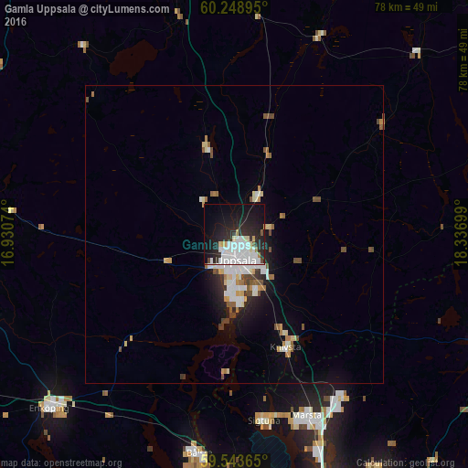
Analysis of Gamla Uppsala night lights 2016
Square area 10x10 km:
 11.26%
90-99
11.36%80-89
2.92%70-79
1.3%60-69
1.19%50-59
0.87%40-49
0.87%30-39
2.27%20-29
18.72%10-19
27.38%0-9
21.86%Square area 50x50 km:
0.95%90-99
1.26%80-89
0.51%70-79
0.42%60-69
0.43%50-59
0.49%40-49
0.65%30-39
0.35%20-29
1.34%10-19
2.73%0-9
90.86%Clear (daylight) street map image can be seen on geolist.org.
Map coordinates:
60° 14' 56.2" North, 16° 55' 50.7" East
59° 53' 53.4" North, 17° 38' 1.9" East
59° 32' 37.1" North, 18° 20' 13.2" East
Some cities around Gamla Uppsala sort by population:
• Uppsala
4.4 km =2.7 mi,  176°
176°
• Märsta
33.1 km =20.6 mi,  158°
158°
• Bålsta
37.3 km =23.2 mi,  189°
189°
• Sävja
9.6 km =6 mi, 157°
• Sigtuna
31.6 km =19.6 mi,  170°
170°
• Knivsta
21 km =13 mi, 155°
• Storvreta
7.9 km =4.9 mi,  30°
30°
• Nykvarn
38.8 km =24.1 mi,  106°
106°
2712993 (p: 16,231)
Sources (retrieved 2019-11-25):
» Earth at Night: Flat Maps 2012, 2016