Umm as Sāhik night lights from space
Night Light of Umm as Sāhik (Eastern Province) from space (Saudi Arabia) Src. Average luminocity for 10x10km area is 74.0208% and for 50x50km: 42.1844%.
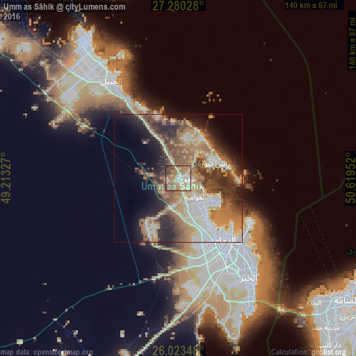
Analysis of Umm as Sāhik night lights 2016
Square area 10x10 km:
 7.2%
7.2%90-99
21.78%80-89
14.2%70-79
12.5%60-69
22.73%50-59
11.17%40-49
5.68%30-39
2.84%20-29
1.89%10-19
0%0-9
0%Square area 50x50 km:
6.66%90-99
8.58%80-89
5.2%70-79
5.81%60-69
9.38%50-59
6.69%40-49
6.1%30-39
6.96%20-29
8.15%10-19
9.04%0-9
27.43%Clear (daylight) street map image can be seen on geolist.org.
Map coordinates:
27° 16' 49" North, 49° 12' 47.8" East
26° 39' 13" North, 49° 54' 59" East
26° 1' 24.5" North, 50° 37' 10.3" East
Some cities around Umm as Sāhik sort by population:
• Dammam
30.7 km =19.1 mi,  142°
142°
• Al Qaţīf
13.4 km =8.3 mi, 136°
• Tārūt
15.2 km =9.4 mi,  125°
125°
• Sayhāt
23 km =14.3 mi,  145°
145°
• Şafwá
3.9 km =2.4 mi,  96°
96°
• Raḩīmah
15.7 km =9.8 mi,  67°
67°
• Al Awjām
10.4 km =6.5 mi,  165°
165°
• At Tūbī
13 km =8.1 mi, 144°
101035 (p: 11,813)
Sources (retrieved 2019-11-25):
» Earth at Night: Flat Maps 2012, 2016