Al Baţţālīyah night lights from space
Night Light of Al Baţţālīyah (Eastern Province) from space (Saudi Arabia) Src. Average luminocity for 10x10km area is 91.5873% and for 50x50km: 36.4988%.
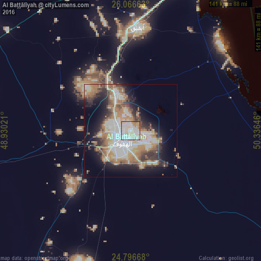
Analysis of Al Baţţālīyah night lights 2016
Square area 10x10 km:
 31.15%
90-99
37.9%80-89
17.26%70-79
5.95%60-69
5.36%50-59
1.59%40-49
0.79%30-39
0%20-29
0%10-19
0%0-9
0%Square area 50x50 km:
7.43%90-99
8.36%80-89
4.31%70-79
4.57%60-69
7.4%50-59
4.06%40-49
3.52%30-39
4.79%20-29
6.29%10-19
10.3%0-9
38.98%Clear (daylight) street map image can be seen on geolist.org.
Map coordinates:
26° 3' 59.9" North, 48° 55' 48.8" East
25° 25' 60" North, 49° 37' 60" East
24° 47' 48" North, 50° 20' 11.3" East
Some cities around Al Baţţālīyah sort by population:
• Al Hufūf
8.9 km =5.5 mi,  211°
211°
• Al Mubarraz
5.2 km =3.2 mi,  236°
236°
• Al Munayzilah
6.5 km =4 mi,  148°
148°
• Al Qurayn
6.5 km =4 mi,  328°
328°
• Al Jubayl
4.1 km =2.5 mi,  155°
155°
• Al Qārah
3.8 km =2.4 mi,  118°
118°
• Al Muţayrifī
9.1 km =5.7 mi,  303°
303°
• Julayjilah
8.1 km =5 mi,  335°
335°
109915 (p: 16,606)
Sources (retrieved 2019-11-25):
» Earth at Night: Flat Maps 2012, 2016