Al Munayzilah night lights from space
Night Light of Al Munayzilah (Eastern Province) from space (Saudi Arabia) Src. Average luminocity for 10x10km area is 90.7421% and for 50x50km: 32.8154%.
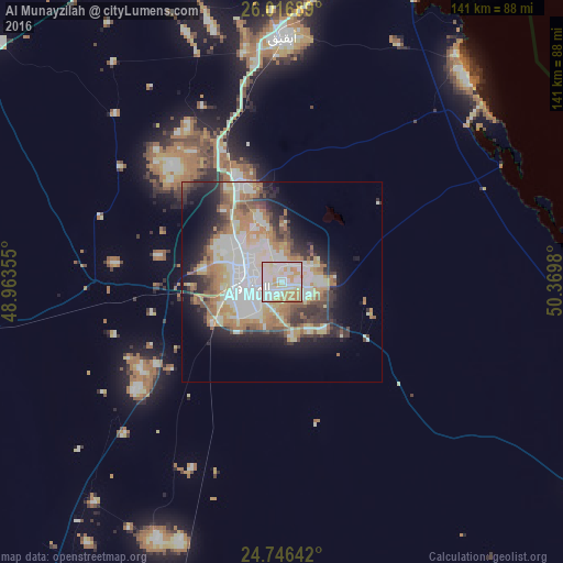
Analysis of Al Munayzilah night lights 2016
Square area 10x10 km:
 26.19%
90-99
37.3%80-89
15.48%70-79
16.27%60-69
4.76%50-59
0%40-49
0%30-39
0%20-29
0%10-19
0%0-9
0%Square area 50x50 km:
7.07%90-99
7.83%80-89
3.94%70-79
4.25%60-69
5.9%50-59
3.34%40-49
3.06%30-39
4.13%20-29
5.45%10-19
9.32%0-9
45.7%Clear (daylight) street map image can be seen on geolist.org.
Map coordinates:
26° 1' 0.8" North, 48° 57' 48.8" East
25° 22' 60" North, 49° 40' 0" East
24° 44' 47.1" North, 50° 22' 11.3" East
Some cities around Al Munayzilah sort by population:
• Al Hufūf
8.2 km =5.1 mi,  255°
255°
• Aţ Ţaraf
6.5 km =4 mi,  110°
110°
• Al Baţţālīyah
6.5 km =4 mi,  328°
328°
• Al Qurayn
13 km =8.1 mi, 328°
• Al Jubayl
2.5 km =1.6 mi,  317°
317°
• Al Qārah
3.7 km =2.3 mi,  0°
0°
• Al Jafr
5.6 km =3.5 mi,  96°
96°
• Al Markaz
6.9 km =4.3 mi,  74°
74°
109059 (p: 16,296)
Sources (retrieved 2019-11-25):
» Earth at Night: Flat Maps 2012, 2016