Al Qārah night lights from space
Night Light of Al Qārah (Eastern Province) from space (Saudi Arabia) Src. Average luminocity for 10x10km area is 87.5337% and for 50x50km: 34.5914%.
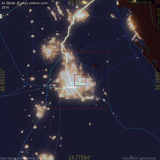
Analysis of Al Qārah night lights 2016
Square area 10x10 km:
 22.82%
90-99
39.48%80-89
14.09%70-79
10.12%60-69
6.15%50-59
1.19%40-49
2.18%30-39
2.98%20-29
0.99%10-19
0%0-9
0%Square area 50x50 km:
7.27%90-99
8.1%80-89
4.16%70-79
4.38%60-69
6.57%50-59
3.73%40-49
3.3%30-39
4.4%20-29
6.02%10-19
9.65%0-9
42.41%Clear (daylight) street map image can be seen on geolist.org.
Map coordinates:
26° 3' 0.2" North, 48° 57' 48.8" East
25° 25' 0" North, 49° 40' 0" East
24° 46' 47.8" North, 50° 22' 11.3" East
Some cities around Al Qārah sort by population:
• Al Hufūf
9.8 km =6.1 mi,  233°
233°
• Al Mubarraz
7.7 km =4.8 mi,  262°
262°
• Aţ Ţaraf
8.6 km =5.3 mi,  134°
134°
• Al Baţţālīyah
3.8 km =2.4 mi,  298°
298°
• Al Munayzilah
3.7 km =2.3 mi,  180°
180°
• Al Jubayl
2.5 km =1.6 mi,  222°
222°
• Al Jafr
7 km =4.3 mi, 128°
• Al Markaz
6.9 km =4.3 mi,  105°
105°
108957 (p: 9,106)
Sources (retrieved 2019-11-25):
» Earth at Night: Flat Maps 2012, 2016