Svetlyy night lights from space
Night Light of Svetlyy (Saratovskaya Oblast) from space (Russia) Src. Average luminocity for 10x10km area is 4.6555% and for 50x50km: 5.7608%.
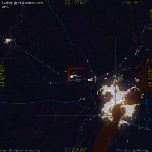
Analysis of Svetlyy night lights 2016
Square area 10x10 km:
 0.42%
0.42%90-99
0.56%80-89
1.26%70-79
0%60-69
1.68%50-59
0.56%40-49
0.7%30-39
0.42%20-29
0%10-19
0%0-9
94.4%Square area 50x50 km:
1.49%90-99
1.48%80-89
0.45%70-79
0.46%60-69
0.58%50-59
0.45%40-49
0.69%30-39
1.06%20-29
1.34%10-19
1.99%0-9
90.02%Clear (daylight) street map image can be seen on geolist.org.
Map coordinates:
52° 6' 27.5" North, 44° 55' 38.7" East
51° 40' 25.3" North, 45° 37' 49.9" East
51° 14' 8" North, 46° 20' 1.2" East
Some cities around Svetlyy sort by population:
• Saratov
30 km =18.6 mi,  119°
119°
• Engel’s
39 km =24.2 mi, 122°
• Privolzhskiy
41.2 km =25.6 mi,  135°
135°
• Atkarsk
48.2 km =30 mi,  297°
297°
• Lysyye Gory
56.2 km =34.9 mi,  255°
255°
• Tatishchevo
2.5 km =1.6 mi, 261°
• Novyye Burasy
59.3 km =36.8 mi,  30°
30°
• Sokolovyy
18.2 km =11.3 mi,  129°
129°
831137 (p: 12,222)
Sources (retrieved 2019-11-25):
» Earth at Night: Flat Maps 2012, 2016