Staryye Atagi night lights from space
Night Light of Staryye Atagi (Chechnya) from space (Russia) Src. Average luminocity for 10x10km area is 23.753% and for 50x50km: 17.6058%.
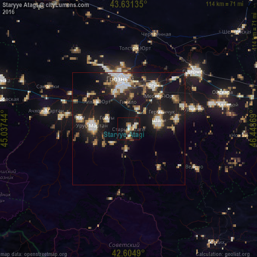
Analysis of Staryye Atagi night lights 2016
Square area 10x10 km:
 1.97%
1.97%90-99
4.09%80-89
3.18%70-79
3.48%60-69
3.18%50-59
2.42%40-49
2.27%30-39
2.27%20-29
3.03%10-19
35.3%0-9
38.79%Square area 50x50 km:
2.38%90-99
3.17%80-89
1.8%70-79
1.58%60-69
2.09%50-59
2.38%40-49
1.88%30-39
2%20-29
4.89%10-19
21.37%0-9
56.46%Clear (daylight) street map image can be seen on geolist.org.
Map coordinates:
43° 37' 52.9" North, 45° 2' 14.8" East
43° 7' 13" North, 45° 44' 26" East
42° 36' 17.6" North, 46° 26' 37.3" East
Some cities around Staryye Atagi sort by population:
• Shali
13.5 km =8.4 mi,  76°
76°
• Goyty
10.7 km =6.6 mi,  297°
297°
• Novyye Atagi
3.1 km =1.9 mi,  57°
57°
• Chechen-Aul
9.7 km =6 mi,  23°
23°
• Duba-Yurt
9.5 km =5.9 mi,  184°
184°
• Alkhazurovo
9.6 km =6 mi,  229°
229°
• Martan-Chu
15.8 km =9.8 mi,  246°
246°
• Chiri-Yurt
3.5 km =2.2 mi, 176°
488128 (p: 10,183)
Sources (retrieved 2019-11-25):
» Earth at Night: Flat Maps 2012, 2016