Chiri-Yurt night lights from space
Night Light of Chiri-Yurt (Chechnya) from space (Russia) Src. Average luminocity for 10x10km area is 20.4394% and for 50x50km: 15.4772%.
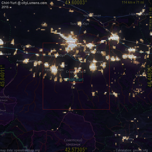
Analysis of Chiri-Yurt night lights 2016
Square area 10x10 km:
 0.91%
0.91%90-99
2.73%80-89
2.88%70-79
4.09%60-69
2.42%50-59
1.97%40-49
3.64%30-39
2.42%20-29
1.21%10-19
25.3%0-9
52.42%Square area 50x50 km:
1.76%90-99
2.58%80-89
1.7%70-79
1.44%60-69
2.05%50-59
2.23%40-49
1.74%30-39
1.82%20-29
4.29%10-19
19.48%0-9
60.92%Clear (daylight) street map image can be seen on geolist.org.
Map coordinates:
43° 36' 0.1" North, 45° 2' 24.4" East
43° 5' 19.3" North, 45° 44' 35.6" East
42° 34' 23" North, 46° 26' 46.9" East
Some cities around Chiri-Yurt sort by population:
• Shali
14.5 km =9 mi,  62°
62°
• Goyty
12.9 km =8 mi,  310°
310°
• Staryye Atagi
3.5 km =2.2 mi,  356°
356°
• Novyye Atagi
5.7 km =3.5 mi,  25°
25°
• Chechen-Aul
12.9 km =8 mi,  16°
16°
• Duba-Yurt
6 km =3.7 mi,  189°
189°
• Alkhazurovo
8 km =5 mi,  249°
249°
• Martan-Chu
15 km =9.3 mi,  259°
259°
568085 (p: 5,136)
Sources (retrieved 2019-11-25):
» Earth at Night: Flat Maps 2012, 2016