Sol’tsy night lights from space
Night Light of Sol’tsy (Novgorod Oblast) from space (Russia) Src. Average luminocity for 10x10km area is 2.6216% and for 50x50km: 0.1482%.
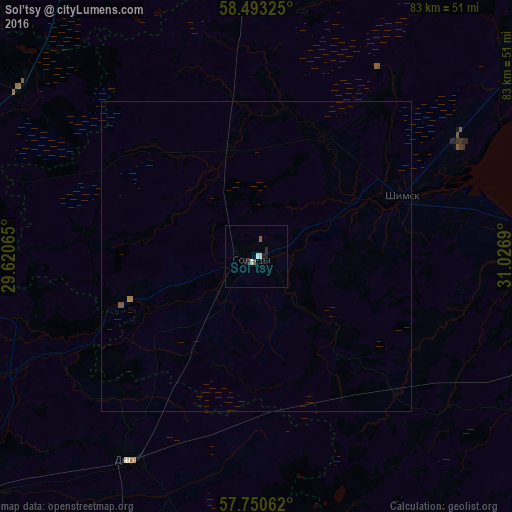
Analysis of Sol’tsy night lights 2016
Square area 10x10 km:
 0.34%
0.34%90-99
1.02%80-89
0%70-79
0%60-69
0%50-59
0.91%40-49
0%30-39
0%20-29
1.14%10-19
1.14%0-9
95.45%Square area 50x50 km:
0.01%90-99
0.04%80-89
0%70-79
0%60-69
0.03%50-59
0.05%40-49
0.02%30-39
0%20-29
0.05%10-19
0.05%0-9
99.75%Clear (daylight) street map image can be seen on geolist.org.
Map coordinates:
58° 29' 35.7" North, 29° 37' 14.3" East
58° 7' 25.9" North, 30° 19' 25.6" East
57° 45' 2.2" North, 31° 1' 36.8" East
Some cities around Sol’tsy sort by population:
• Velikiy Novgorod
70.8 km =44 mi,  51°
51°
• Luga
73.7 km =45.8 mi,  337°
337°
• Staraya Russa
62.7 km =39 mi,  103°
103°
• Porkhov
60.4 km =37.5 mi,  228°
228°
• Pankovka
66.1 km =41.1 mi, 50°
• Dno
39.2 km =24.4 mi,  212°
212°
• Dedovichi
67.4 km =41.9 mi,  199°
199°
• Strugi-Krasnyye
72.8 km =45.2 mi,  282°
282°
490750 (p: 10,625)
Sources (retrieved 2019-11-25):
» Earth at Night: Flat Maps 2012, 2016