Pribrezhnyy night lights from space
Night Light of Pribrezhnyy (Samara Oblast) from space (Russia) Src. Average luminocity for 10x10km area is 2.2169% and for 50x50km: 5.9468%.
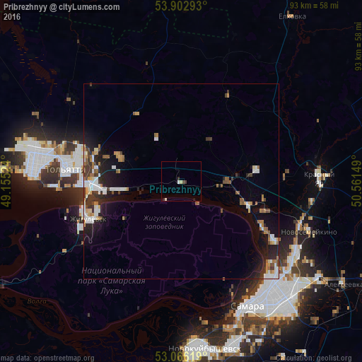
Analysis of Pribrezhnyy night lights 2016
Square area 10x10 km:
 0.4%
0.4%90-99
0.4%80-89
0.53%70-79
0%60-69
0%50-59
0%40-49
1.06%30-39
0.53%20-29
0.13%10-19
0.4%0-9
96.56%Square area 50x50 km:
1.17%90-99
0.98%80-89
0.4%70-79
0.52%60-69
0.94%50-59
0.69%40-49
0.61%30-39
1.01%20-29
1.64%10-19
3.94%0-9
88.09%Clear (daylight) street map image can be seen on geolist.org.
Map coordinates:
53° 54' 10.5" North, 49° 9' 18.9" East
53° 29' 11.8" North, 49° 51' 30.1" East
53° 3' 58.3" North, 50° 33' 41.4" East
Some cities around Pribrezhnyy sort by population:
• Tol’yatti
34.2 km =21.3 mi,  278°
278°
• Zhigulevsk
25.9 km =16.1 mi,  248°
248°
• Povolzhskiy
12.7 km =7.9 mi,  330°
330°
• Mirnyy
27.7 km =17.2 mi,  85°
85°
• Volzhskiy
18.3 km =11.4 mi,  109°
109°
• Kurumoch
11.9 km =7.4 mi, 88°
• Berëza
18.9 km =11.7 mi,  79°
79°
• Rozhdestveno
30.8 km =19.1 mi,  154°
154°
7117224 (p: 11,500)
Sources (retrieved 2019-11-25):
» Earth at Night: Flat Maps 2012, 2016