Povolzhskiy night lights from space
Night Light of Povolzhskiy (Samara Oblast) from space (Russia) Src. Average luminocity for 10x10km area is 1.8611% and for 50x50km: 7.4372%.
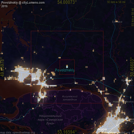
Analysis of Povolzhskiy night lights 2016
Square area 10x10 km:
 0.76%
0.76%90-99
0.25%80-89
0%70-79
0%60-69
0.63%50-59
0.38%40-49
0%30-39
0%20-29
0%10-19
0%0-9
97.98%Square area 50x50 km:
1.81%90-99
1.58%80-89
0.55%70-79
0.62%60-69
0.68%50-59
0.68%40-49
0.72%30-39
1.52%20-29
2.15%10-19
4.11%0-9
85.6%Clear (daylight) street map image can be seen on geolist.org.
Map coordinates:
54° 0' 2.6" North, 49° 3' 35.2" East
53° 35' 7.4" North, 49° 45' 46.4" East
53° 9' 57.4" North, 50° 27' 57.7" East
Some cities around Povolzhskiy sort by population:
• Tol’yatti
28.2 km =17.5 mi,  257°
257°
• Zhigulevsk
27.2 km =16.9 mi,  220°
220°
• Pribrezhnyy
12.7 km =7.9 mi,  150°
150°
• Krasnyy Yar
42.7 km =26.5 mi,  102°
102°
• Mirnyy
35.1 km =21.8 mi, 104°
• Volzhskiy
29.2 km =18.1 mi,  126°
126°
• Kurumoch
21 km =13 mi,  120°
120°
• Berëza
26 km =16.2 mi,  106°
106°
867006 (p: 8,952)
Sources (retrieved 2019-11-25):
» Earth at Night: Flat Maps 2012, 2016