Pokachi night lights from space
Night Light of Pokachi (Khanty-Mansia) from space (Russia) Src. Average luminocity for 10x10km area is 20.999% and for 50x50km: 3.5787%.
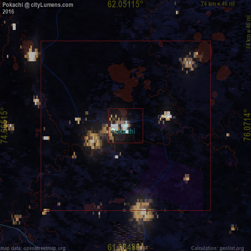
Analysis of Pokachi night lights 2016
Square area 10x10 km:
 3.26%
3.26%90-99
4.25%80-89
0.69%70-79
2.67%60-69
1.78%50-59
4.35%40-49
2.27%30-39
1.88%20-29
3.66%10-19
26.09%0-9
49.11%Square area 50x50 km:
0.28%90-99
0.3%80-89
0.38%70-79
0.4%60-69
0.53%50-59
0.66%40-49
0.65%30-39
0.63%20-29
0.75%10-19
3.23%0-9
92.2%Clear (daylight) street map image can be seen on geolist.org.
Map coordinates:
62° 3' 4.1" North, 74° 39' 54.5" East
61° 43' 11.4" North, 75° 22' 5.8" East
61° 23' 5.6" North, 76° 4' 17" East
Some cities around Pokachi sort by population:
• Surgut
116 km =72.1 mi,  243°
243°
• Nizhnevartovsk
107.8 km =67 mi,  144°
144°
• Kogalym
76.4 km =47.5 mi,  322°
322°
• Megion
86.4 km =53.7 mi,  152°
152°
• Langepas
52.4 km =32.6 mi,  189°
189°
• Fedorovskiy
88.2 km =54.8 mi,  261°
261°
• Izluchinsk
116.9 km =72.6 mi,  134°
134°
• Novoagansk
72.4 km =45 mi,  69°
69°
7289676 (p: 17,084)
Sources (retrieved 2019-11-25):
» Earth at Night: Flat Maps 2012, 2016