Izluchinsk night lights from space
Night Light of Izluchinsk (Khanty-Mansia) from space (Russia) Src. Average luminocity for 10x10km area is 27.2469% and for 50x50km: 7.3288%.
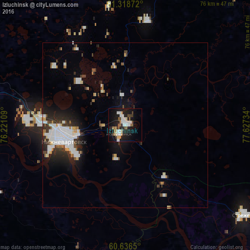
Analysis of Izluchinsk night lights 2016
Square area 10x10 km:
 6.4%
6.4%90-99
5.58%80-89
2.27%70-79
1.96%60-69
2.27%50-59
3.1%40-49
2.58%30-39
1.45%20-29
6.71%10-19
28.93%0-9
38.74%Square area 50x50 km:
1.88%90-99
1.59%80-89
0.48%70-79
0.5%60-69
0.52%50-59
0.53%40-49
0.7%30-39
0.95%20-29
2.04%10-19
4.05%0-9
86.77%Clear (daylight) street map image can be seen on geolist.org.
Map coordinates:
61° 19' 7.4" North, 76° 13' 15.9" East
60° 58' 46" North, 76° 55' 27.2" East
60° 38' 11.4" North, 77° 37' 38.4" East
Some cities around Izluchinsk sort by population:
• Nizhnevartovsk
20.6 km =12.8 mi,  255°
255°
• Megion
44 km =27.3 mi,  277°
277°
• Raduzhny
127.5 km =79.2 mi,  13°
13°
• Strezhevoy
45.2 km =28.1 mi,  127°
127°
• Langepas
96.9 km =60.2 mi,  288°
288°
• Fedorovskiy
185 km =115 mi, 292°
• Pokachi
116.9 km =72.6 mi,  314°
314°
• Novoagansk
108.2 km =67.2 mi,  352°
352°
7290697 (p: 18,000)
Sources (retrieved 2019-11-25):
» Earth at Night: Flat Maps 2012, 2016