Pestretsy night lights from space
Night Light of Pestretsy (Tatarstan Republic) from space (Russia) Src. Average luminocity for 10x10km area is 3.5096% and for 50x50km: 3.3672%.
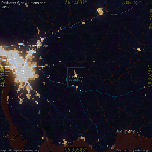
Analysis of Pestretsy night lights 2016
Square area 10x10 km:
 0%
0%90-99
0.36%80-89
0.84%70-79
0.24%60-69
0.96%50-59
1.08%40-49
0.6%30-39
0.24%20-29
0%10-19
0%0-9
95.69%Square area 50x50 km:
0.28%90-99
0.41%80-89
0.36%70-79
0.47%60-69
0.6%50-59
0.65%40-49
0.35%30-39
0.31%20-29
1.08%10-19
3.07%0-9
92.43%Clear (daylight) street map image can be seen on geolist.org.
Map coordinates:
56° 8' 48.6" North, 48° 57' 5.1" East
55° 45' 11.3" North, 49° 39' 16.3" East
55° 21' 19.5" North, 50° 21' 27.6" East
Some cities around Pestretsy sort by population:
• Kazan
33.5 km =20.8 mi,  276°
276°
• Arsk
40.1 km =24.9 mi,  20°
20°
• Vysokaya Gora
28.3 km =17.6 mi,  308°
308°
• Osinovo
50.4 km =31.3 mi,  286°
286°
• Laishevo
39.3 km =24.4 mi,  189°
189°
• Bogatyye Saby
57.2 km =35.5 mi,  59°
59°
• Rybnaya Sloboda
44.6 km =27.7 mi,  136°
136°
• Staroye Arakchino
43.1 km =26.8 mi, 277°
510342 (p: 7,311)
Sources (retrieved 2019-11-25):
» Earth at Night: Flat Maps 2012, 2016