Osinovo night lights from space
Night Light of Osinovo (Tatarstan Republic) from space (Russia) Src. Average luminocity for 10x10km area is 62.2794% and for 50x50km: 20.247%.
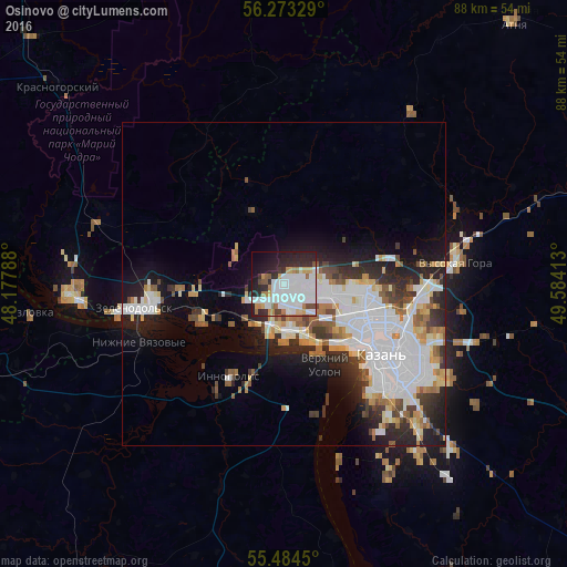
Analysis of Osinovo night lights 2016
Square area 10x10 km:
 23.68%
90-99
18.42%80-89
2.76%70-79
5.14%60-69
5.01%50-59
3.01%40-49
3.13%30-39
5.76%20-29
17.04%10-19
12.03%0-9
4.01%Square area 50x50 km:
6.67%90-99
4.36%80-89
1.7%70-79
1.83%60-69
1.76%50-59
1.92%40-49
1.44%30-39
2.41%20-29
4.78%10-19
7.18%0-9
65.97%Clear (daylight) street map image can be seen on geolist.org.
Map coordinates:
56° 16' 23.8" North, 48° 10' 40.4" East
55° 52' 51.2" North, 48° 52' 51.6" East
55° 29' 4.2" North, 49° 35' 2.9" East
Some cities around Osinovo sort by population:
• Kazan
18.2 km =11.3 mi,  124°
124°
• Zelenodolsk
23 km =14.3 mi,  259°
259°
• Volzhsk
32.6 km =20.3 mi,  267°
267°
• Vasil’yevo
11.7 km =7.3 mi,  241°
241°
• Kozlovka
39.6 km =24.6 mi, 263°
• Nizhniye Vyazovyye
24 km =14.9 mi,  247°
247°
• Vysokaya Gora
26.5 km =16.5 mi,  82°
82°
• Staroye Arakchino
10.2 km =6.3 mi,  146°
146°
514460 (p: 7,827)
Sources (retrieved 2019-11-25):
» Earth at Night: Flat Maps 2012, 2016