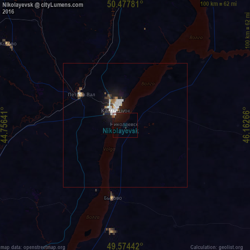
Nikolayevsk night lights from space
Night Light of Nikolayevsk (Volgograd Oblast) from space (Russia) Src. Average luminocity for 10x10km area is 4.5658% and for 50x50km: 1.9162%.
Analysis of Nikolayevsk night lights 2016
Square area 10x10 km:
 0.98%
0.98%90-99
0.42%80-89
0%70-79
0.56%60-69
0.14%50-59
0.14%40-49
0%30-39
0%20-29
1.26%10-19
9.38%0-9
87.11%Square area 50x50 km:
0.44%90-99
0.45%80-89
0.05%70-79
0.05%60-69
0.21%50-59
0.25%40-49
0.11%30-39
0.22%20-29
0.37%10-19
1.86%0-9
95.98%Clear (daylight) street map image can be seen on geolist.org.
Map coordinates:
50° 28' 40.1" North, 44° 45' 23.1" East
50° 1' 41.7" North, 45° 27' 34.3" East
49° 34' 27.9" North, 46° 9' 45.6" East
Some cities around Nikolayevsk sort by population:
• Kamyshin
8.4 km =5.2 mi,  338°
338°
• Kotovo
57.1 km =35.5 mi,  304°
304°
• Pallasovka
101.7 km =63.2 mi,  88°
88°
• Petrov Val
22 km =13.7 mi,  305°
305°
• Bykovo
29.6 km =18.4 mi,  189°
189°
• Krasnyy Yar
90.6 km =56.3 mi,  325°
325°
• Danilovka
102.3 km =63.6 mi,  290°
290°
• Rovnoye
93.2 km =57.9 mi,  26°
26°
521874 (p: 16,044)
Sources (retrieved 2019-11-25):
» Earth at Night: Flat Maps 2012, 2016