Mutsalaul night lights from space
Night Light of Mutsalaul (Dagestan) from space (Russia) Src. Average luminocity for 10x10km area is 15.1076% and for 50x50km: 9.7636%.
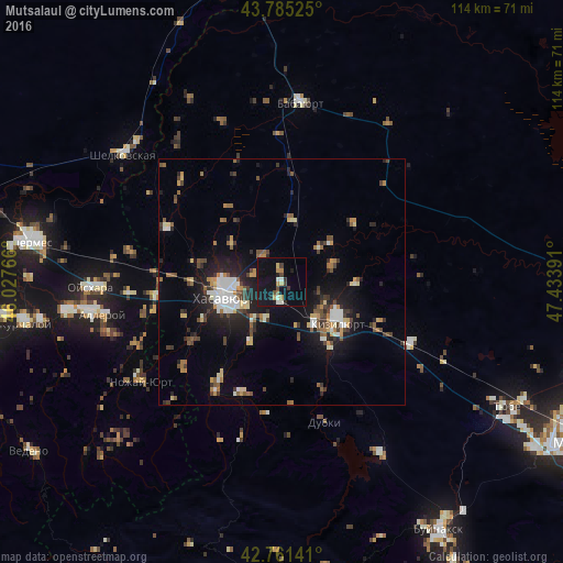
Analysis of Mutsalaul night lights 2016
Square area 10x10 km:
 0.45%
0.45%90-99
2.58%80-89
1.21%70-79
1.36%60-69
2.42%50-59
0.76%40-49
2.73%30-39
1.21%20-29
2.12%10-19
23.03%0-9
62.12%Square area 50x50 km:
1.07%90-99
1.51%80-89
0.88%70-79
1.09%60-69
1.06%50-59
1.31%40-49
1.74%30-39
1.38%20-29
2.65%10-19
7.07%0-9
80.22%Clear (daylight) street map image can be seen on geolist.org.
Map coordinates:
43° 47' 6.9" North, 46° 1' 39.6" East
43° 16' 31.7" North, 46° 43' 50.8" East
42° 45' 41.1" North, 47° 26' 2.1" East
Some cities around Mutsalaul sort by population:
• Khasavyurt
11.9 km =7.4 mi,  256°
256°
• Kizilyurt
15.8 km =9.8 mi,  127°
127°
• Chontaul
10.9 km =6.8 mi,  72°
72°
• Dylym
24 km =14.9 mi,  198°
198°
• Leninaul
24.1 km =15 mi,  211°
211°
• Endirey
14 km =8.7 mi, 206°
• Novyy Sulak
13 km =8.1 mi,  143°
143°
• Bavtugay
14.6 km =9.1 mi, 144°
524113 (p: 6,219)
Sources (retrieved 2019-11-25):
» Earth at Night: Flat Maps 2012, 2016