Endirey night lights from space
Night Light of Endirey (Dagestan) from space (Russia) Src. Average luminocity for 10x10km area is 13.1621% and for 50x50km: 10.7137%.
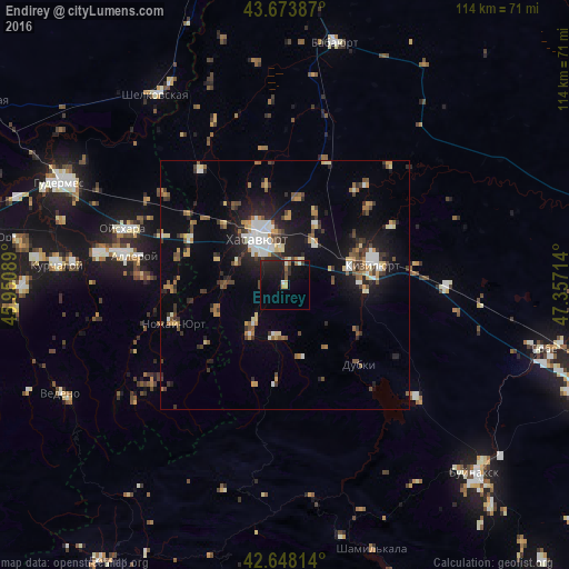
Analysis of Endirey night lights 2016
Square area 10x10 km:
 0.15%
0.15%90-99
2.27%80-89
1.21%70-79
1.06%60-69
1.67%50-59
0.76%40-49
2.73%30-39
0.45%20-29
6.52%10-19
16.52%0-9
66.67%Square area 50x50 km:
1.09%90-99
1.65%80-89
0.94%70-79
1.33%60-69
1.19%50-59
1.45%40-49
1.76%30-39
1.64%20-29
2.73%10-19
7.26%0-9
78.97%Clear (daylight) street map image can be seen on geolist.org.
Map coordinates:
43° 40' 25.9" North, 45° 57' 3.2" East
43° 9' 47.4" North, 46° 39' 14.4" East
42° 38' 53.3" North, 47° 21' 25.7" East
Some cities around Endirey sort by population:
• Khasavyurt
11.1 km =6.9 mi,  331°
331°
• Kizilyurt
18.9 km =11.7 mi,  81°
81°
• Dylym
10.4 km =6.5 mi,  188°
188°
• Leninaul
10.3 km =6.4 mi,  219°
219°
• Mutsalaul
14 km =8.7 mi,  26°
26°
• Dubki
21.7 km =13.5 mi,  136°
136°
• Novyy Sulak
14.1 km =8.8 mi, 81°
• Bavtugay
14.6 km =9.1 mi,  87°
87°
582097 (p: 6,927)
Sources (retrieved 2019-11-25):
» Earth at Night: Flat Maps 2012, 2016