Chontaul night lights from space
Night Light of Chontaul (Dagestan) from space (Russia) Src. Average luminocity for 10x10km area is 12.1333% and for 50x50km: 8.2621%.
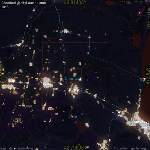
Analysis of Chontaul night lights 2016
Square area 10x10 km:
 0.45%
0.45%90-99
1.52%80-89
0.91%70-79
1.67%60-69
3.18%50-59
0.76%40-49
2.12%30-39
1.52%20-29
2.42%10-19
4.7%0-9
80.76%Square area 50x50 km:
1.06%90-99
1.5%80-89
0.76%70-79
0.92%60-69
0.83%50-59
0.94%40-49
1.37%30-39
1.06%20-29
2.23%10-19
6.06%0-9
83.29%Clear (daylight) street map image can be seen on geolist.org.
Map coordinates:
43° 48' 51.6" North, 46° 9' 23.6" East
43° 18' 17.3" North, 46° 51' 34.8" East
42° 47' 27.5" North, 47° 33' 46.1" East
Some cities around Chontaul sort by population:
• Khasavyurt
22.8 km =14.2 mi,  254°
254°
• Kizilyurt
13.1 km =8.1 mi,  170°
170°
• Novyy Chirkey
22.5 km =14 mi,  134°
134°
• Endirey
22.9 km =14.2 mi,  226°
226°
• Mutsalaul
10.9 km =6.8 mi, 252°
• Dubki
31.6 km =19.6 mi,  183°
183°
• Novyy Sulak
14 km =8.7 mi,  191°
191°
• Bavtugay
15.3 km =9.5 mi, 187°
567859 (p: 8,241)
Sources (retrieved 2019-11-25):
» Earth at Night: Flat Maps 2012, 2016