Murygino night lights from space
Night Light of Murygino (Kirov) from space (Russia) Src. Average luminocity for 10x10km area is 0.0045% and for 50x50km: 5.8938%.
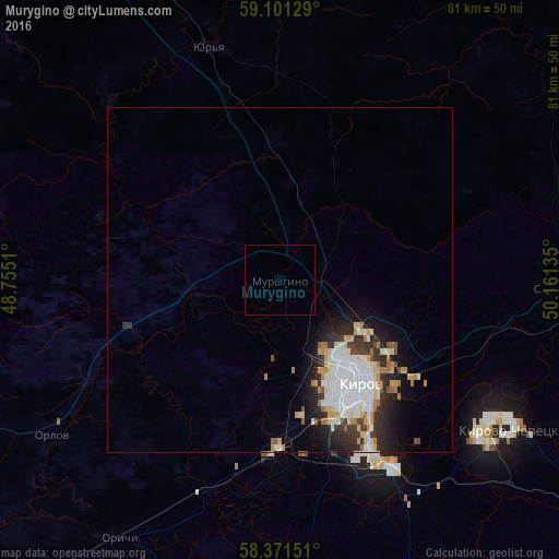
Analysis of Murygino night lights 2016
Square area 10x10 km:
 0%
0%90-99
0%80-89
0%70-79
0%60-69
0%50-59
0%40-49
0%30-39
0%20-29
0%10-19
0%0-9
100%Square area 50x50 km:
1.7%90-99
1.23%80-89
0.62%70-79
0.53%60-69
0.71%50-59
0.3%40-49
0.31%30-39
0.81%20-29
1.76%10-19
2.56%0-9
89.48%Clear (daylight) street map image can be seen on geolist.org.
Map coordinates:
59° 6' 4.6" North, 48° 45' 18.4" East
58° 44' 17.9" North, 49° 27' 29.6" East
58° 22' 17.4" North, 50° 9' 40.9" East
Some cities around Murygino sort by population:
• Kirov
19.6 km =12.2 mi,  143°
143°
• Kirovo-Chepetsk
39.4 km =24.5 mi,  121°
121°
• Slobodskoy
41.5 km =25.8 mi,  90°
90°
• Lyangasovo
24.6 km =15.3 mi,  181°
181°
• Raduzhnyy
28.7 km =17.8 mi,  158°
158°
• Vakhrushi
33.3 km =20.7 mi,  100°
100°
• Orlov
39.5 km =24.5 mi,  236°
236°
• Orichi
43.9 km =27.3 mi,  211°
211°
524243 (p: 7,996)
Sources (retrieved 2019-11-25):
» Earth at Night: Flat Maps 2012, 2016