Kugesi night lights from space
Night Light of Kugesi (Chuvashia) from space (Russia) Src. Average luminocity for 10x10km area is 16.0013% and for 50x50km: 6.7892%.
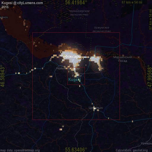
Analysis of Kugesi night lights 2016
Square area 10x10 km:
 0.88%
0.88%90-99
2.63%80-89
1%70-79
4.01%60-69
1.5%50-59
1.13%40-49
0.88%30-39
0.5%20-29
8.02%10-19
19.92%0-9
59.52%Square area 50x50 km:
1.57%90-99
1.4%80-89
0.49%70-79
0.77%60-69
0.62%50-59
0.56%40-49
0.52%30-39
0.72%20-29
2.26%10-19
5.08%0-9
86.03%Clear (daylight) street map image can be seen on geolist.org.
Map coordinates:
56° 25' 11.4" North, 46° 35' 21.9" East
56° 1' 44.2" North, 47° 17' 33.2" East
55° 38' 2.6" North, 47° 59' 44.4" East
Some cities around Kugesi sort by population:
• Cheboksary
11.8 km =7.3 mi,  347°
347°
• Novocheboksarsk
14.7 km =9.1 mi,  51°
51°
• Koz’modem’yansk
57 km =35.4 mi,  307°
307°
• Tsivil’sk
21.2 km =13.2 mi,  146°
146°
• Zvenigovo
45.2 km =28.1 mi,  97°
97°
• Mariinskiy Posad
28.1 km =17.5 mi,  70°
70°
• Novyye Lapsary
6.6 km =4.1 mi, 312°
• Urmary
56.3 km =35 mi,  133°
133°
539794 (p: 11,547)
Sources (retrieved 2019-11-25):
» Earth at Night: Flat Maps 2012, 2016