Mariinskiy Posad night lights from space
Night Light of Mariinskiy Posad (Chuvashia) from space (Russia) Src. Average luminocity for 10x10km area is 0.2811% and for 50x50km: 2.3428%.
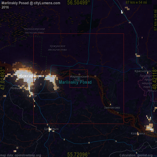
Analysis of Mariinskiy Posad night lights 2016
Square area 10x10 km:
 0%
0%90-99
0%80-89
0%70-79
0%60-69
0%50-59
0%40-49
0%30-39
0%20-29
0.96%10-19
0%0-9
99.04%Square area 50x50 km:
0.36%90-99
0.39%80-89
0.21%70-79
0.24%60-69
0.33%50-59
0.17%40-49
0.13%30-39
0.12%20-29
0.82%10-19
3.05%0-9
94.18%Clear (daylight) street map image can be seen on geolist.org.
Map coordinates:
56° 30' 18" North, 47° 0' 53.7" East
56° 6' 53.9" North, 47° 43' 5" East
55° 43' 15.5" North, 48° 25' 16.2" East
Some cities around Mariinskiy Posad sort by population:
• Cheboksary
29 km =18 mi,  273°
273°
• Novocheboksarsk
14.9 km =9.3 mi, 268°
• Tsivil’sk
31.1 km =19.3 mi,  208°
208°
• Zvenigovo
24 km =14.9 mi,  130°
130°
• Kozlovka
44.8 km =27.8 mi, 132°
• Kugesi
28.1 km =17.5 mi,  250°
250°
• Novyye Lapsary
31.7 km =19.7 mi,  260°
260°
• Krasnogorskiy
37.9 km =23.5 mi,  83°
83°
529343 (p: 10,199)
Sources (retrieved 2019-11-25):
» Earth at Night: Flat Maps 2012, 2016