Tsivil’sk night lights from space
Night Light of Tsivil’sk (Chuvashia) from space (Russia) Src. Average luminocity for 10x10km area is 3.287% and for 50x50km: 1.824%.
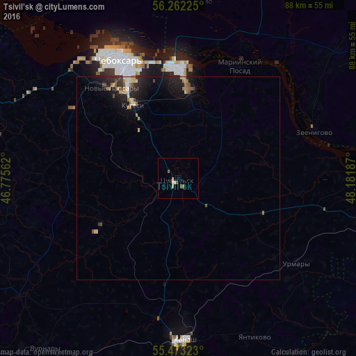
Analysis of Tsivil’sk night lights 2016
Square area 10x10 km:
 0.25%
0.25%90-99
0.75%80-89
0%70-79
1%60-69
0.13%50-59
1.88%40-49
0%30-39
0%20-29
0%10-19
0%0-9
95.99%Square area 50x50 km:
0.09%90-99
0.2%80-89
0.22%70-79
0.29%60-69
0.26%50-59
0.29%40-49
0.21%30-39
0.2%20-29
0.74%10-19
1.82%0-9
95.69%Clear (daylight) street map image can be seen on geolist.org.
Map coordinates:
56° 15' 44.1" North, 46° 46' 32.2" East
55° 52' 11.1" North, 47° 28' 43.5" East
55° 28' 23.6" North, 48° 10' 54.7" East
Some cities around Tsivil’sk sort by population:
• Cheboksary
32.4 km =20.1 mi,  334°
334°
• Novocheboksarsk
26.8 km =16.7 mi,  359°
359°
• Kanash
40 km =24.9 mi,  178°
178°
• Zvenigovo
35.3 km =21.9 mi,  70°
70°
• Kugesi
21.2 km =13.2 mi, 326°
• Mariinskiy Posad
31.1 km =19.3 mi,  28°
28°
• Novyye Lapsary
27.6 km =17.1 mi,  323°
323°
• Urmary
36 km =22.4 mi,  126°
126°
480851 (p: 13,252)
Sources (retrieved 2019-11-25):
» Earth at Night: Flat Maps 2012, 2016