Krasnogorskiy night lights from space
Night Light of Krasnogorskiy (Mariy-El Republic) from space (Russia) Src. Average luminocity for 10x10km area is 0.622% and for 50x50km: 0.2096%.
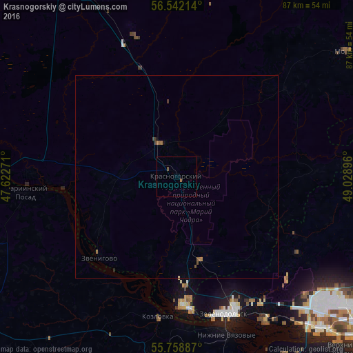
Analysis of Krasnogorskiy night lights 2016
Square area 10x10 km:
 0%
0%90-99
0%80-89
0%70-79
0%60-69
0.48%50-59
0.48%40-49
0%30-39
0%20-29
0%10-19
0%0-9
99.04%Square area 50x50 km:
0%90-99
0%80-89
0.01%70-79
0%60-69
0.11%50-59
0.09%40-49
0.04%30-39
0.04%20-29
0.02%10-19
0%0-9
99.68%Clear (daylight) street map image can be seen on geolist.org.
Map coordinates:
56° 32' 31.7" North, 47° 37' 21.8" East
56° 9' 9" North, 48° 19' 33" East
55° 45' 31.9" North, 49° 1' 44.3" East
Some cities around Krasnogorskiy sort by population:
• Zelenodolsk
36.3 km =22.6 mi,  160°
160°
• Volzhsk
31.9 km =19.8 mi,  176°
176°
• Vasil’yevo
43.3 km =26.9 mi,  145°
145°
• Zvenigovo
27.7 km =17.2 mi,  224°
224°
• Kozlovka
34.8 km =21.6 mi,  187°
187°
• Mariinskiy Posad
37.9 km =23.5 mi,  263°
263°
• Nizhniye Vyazovyye
41.2 km =25.6 mi, 162°
• Osinovo
45.9 km =28.5 mi,  131°
131°
542366 (p: 7,065)
Sources (retrieved 2019-11-25):
» Earth at Night: Flat Maps 2012, 2016