Krasnobrodskiy night lights from space
Night Light of Krasnobrodskiy (Kemerovo Oblast) from space (Russia) Src. Average luminocity for 10x10km area is 35.6768% and for 50x50km: 9.0076%.
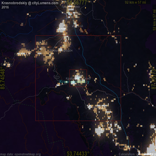
Analysis of Krasnobrodskiy night lights 2016
Square area 10x10 km:
 7.07%
7.07%90-99
7.45%80-89
6.19%70-79
3.79%60-69
3.79%50-59
2.53%40-49
1.01%30-39
0.76%20-29
10.61%10-19
38.38%0-9
18.43%Square area 50x50 km:
0.81%90-99
1.04%80-89
0.88%70-79
1.24%60-69
1.77%50-59
1.77%40-49
1.17%30-39
0.3%20-29
2.68%10-19
9.26%0-9
79.08%Clear (daylight) street map image can be seen on geolist.org.
Map coordinates:
54° 34' 4" North, 85° 44' 43.7" East
54° 9' 29.2" North, 86° 26' 55" East
53° 44' 39.6" North, 87° 9' 6.2" East
Some cities around Krasnobrodskiy sort by population:
• Prokop’yevsk
33.1 km =20.6 mi,  147°
147°
• Kiselëvsk
23.3 km =14.5 mi,  143°
143°
• Belovo
30.4 km =18.9 mi,  341°
341°
• Gur’yevsk
36.3 km =22.6 mi,  292°
292°
• Bachatskiy
25.6 km =15.9 mi,  305°
305°
• Gramoteino
42.3 km =26.3 mi,  354°
354°
• Inskoy
30.2 km =18.8 mi,  358°
358°
• Salair
43.1 km =26.8 mi,  280°
280°
1484871 (p: 11,565)
Sources (retrieved 2019-11-25):
» Earth at Night: Flat Maps 2012, 2016