Gramoteino night lights from space
Night Light of Gramoteino (Kemerovo Oblast) from space (Russia) Src. Average luminocity for 10x10km area is 32.5455% and for 50x50km: 11.8225%.
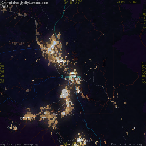
Analysis of Gramoteino night lights 2016
Square area 10x10 km:
 4.55%
4.55%90-99
6.94%80-89
3.47%70-79
1.91%60-69
3.59%50-59
3.83%40-49
4.43%30-39
4.19%20-29
10.53%10-19
40.91%0-9
15.67%Square area 50x50 km:
1.26%90-99
1.68%80-89
0.98%70-79
1.19%60-69
2.04%50-59
2.51%40-49
2.1%30-39
1.82%20-29
4.03%10-19
9.18%0-9
73.21%Clear (daylight) street map image can be seen on geolist.org.
Map coordinates:
54° 56' 33.7" North, 85° 40' 50.8" East
54° 32' 12.5" North, 86° 23' 2" East
54° 7' 36.6" North, 87° 5' 13.3" East
Some cities around Gramoteino sort by population:
• Leninsk-Kuznetsky
19 km =11.8 mi,  314°
314°
• Belovo
14.5 km =9 mi,  202°
202°
• Polysayevo
11.4 km =7.1 mi, 308°
• Gur’yevsk
40.6 km =25.2 mi,  225°
225°
• Bachatskiy
31.8 km =19.8 mi,  211°
211°
• Inskoy
12.4 km =7.7 mi,  163°
163°
• Krasnobrodskiy
42.3 km =26.3 mi,  174°
174°
• Salair
51 km =31.7 mi, 228°
1506192 (p: 14,010)
Sources (retrieved 2019-11-25):
» Earth at Night: Flat Maps 2012, 2016