Bachatskiy night lights from space
Night Light of Bachatskiy (Kemerovo Oblast) from space (Russia) Src. Average luminocity for 10x10km area is 38.0752% and for 50x50km: 10.3778%.
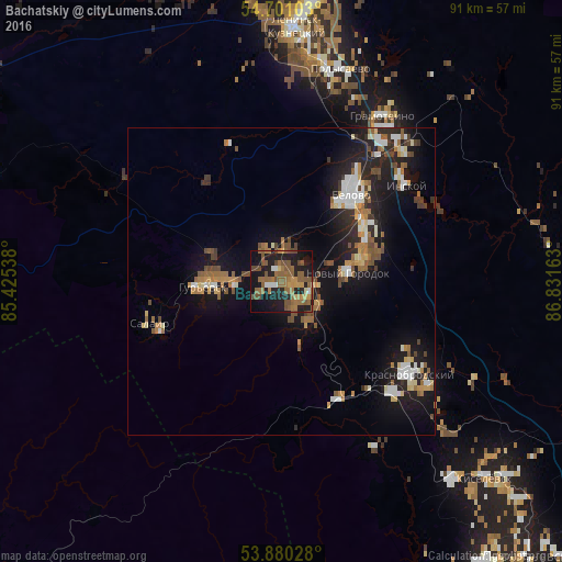
Analysis of Bachatskiy night lights 2016
Square area 10x10 km:
 1.63%
1.63%90-99
1.88%80-89
1.75%70-79
5.39%60-69
14.04%50-59
16.04%40-49
8.15%30-39
0%20-29
10.78%10-19
32.58%0-9
7.77%Square area 50x50 km:
1.14%90-99
1.43%80-89
0.91%70-79
1.16%60-69
1.97%50-59
1.86%40-49
1.48%30-39
0.73%20-29
3.18%10-19
9.62%0-9
76.5%Clear (daylight) street map image can be seen on geolist.org.
Map coordinates:
54° 42' 3.7" North, 85° 25' 31.4" East
54° 17' 33.7" North, 86° 7' 42.6" East
53° 52' 49" North, 86° 49' 53.9" East
Some cities around Bachatskiy sort by population:
• Leninsk-Kuznetsky
40.6 km =25.2 mi,  4°
4°
• Belovo
17.6 km =10.9 mi,  38°
38°
• Polysayevo
35.1 km =21.8 mi,  12°
12°
• Gur’yevsk
12.7 km =7.9 mi,  265°
265°
• Gramoteino
31.8 km =19.8 mi,  31°
31°
• Inskoy
25.3 km =15.7 mi,  52°
52°
• Krasnobrodskiy
25.6 km =15.9 mi,  125°
125°
• Salair
22.6 km =14 mi,  252°
252°
1511103 (p: 14,618)
Sources (retrieved 2019-11-25):
» Earth at Night: Flat Maps 2012, 2016