Kommunar night lights from space
Night Light of Kommunar (Leningradskaya Oblast') from space (Russia) Src. Average luminocity for 10x10km area is 7.7506% and for 50x50km: 23.6543%.
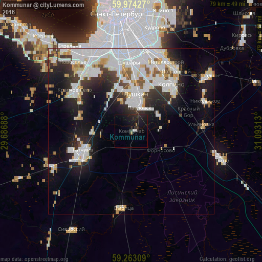
Analysis of Kommunar night lights 2016
Square area 10x10 km:
 0.57%
0.57%90-99
0.79%80-89
0.57%70-79
0.34%60-69
0%50-59
0%40-49
0%30-39
2.49%20-29
5.33%10-19
15.76%0-9
74.15%Square area 50x50 km:
8.41%90-99
5.94%80-89
2.03%70-79
2.2%60-69
0.83%50-59
1.32%40-49
1.04%30-39
2.53%20-29
4.92%10-19
9.86%0-9
60.92%Clear (daylight) street map image can be seen on geolist.org.
Map coordinates:
59° 58' 27.4" North, 29° 41' 12.8" East
59° 37' 14" North, 30° 23' 24" East
59° 15' 47.1" North, 31° 5' 35.3" East
Some cities around Kommunar sort by population:
• Kolpino
18.3 km =11.4 mi,  37°
37°
• Pushkin
10.4 km =6.5 mi,  1°
1°
• Gatchina
15.5 km =9.6 mi,  251°
251°
• Krasnoye Selo
21.4 km =13.3 mi,  307°
307°
• Pavlovsk
7.4 km =4.6 mi,  19°
19°
• Shushary
21 km =13 mi,  358°
358°
• Ul’yanovka
21.2 km =13.2 mi,  84°
84°
• Mariyenburg
19.1 km =11.9 mi, 253°
545788 (p: 17,358)
Sources (retrieved 2019-11-25):
» Earth at Night: Flat Maps 2012, 2016