Kastanayevo night lights from space
Night Light of Kastanayevo (Moscow Oblast) from space (Russia) Src. Average luminocity for 10x10km area is 99.1687% and for 50x50km: 83.6833%.
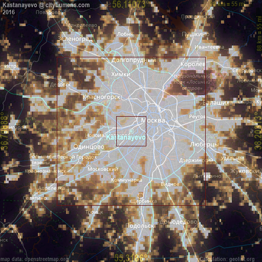
Analysis of Kastanayevo night lights 2016
Square area 10x10 km:
 85.89%
90-99
10.65%80-89
3.47%70-79
0%60-69
0%50-59
0%40-49
0%30-39
0%20-29
0%10-19
0%0-9
0%Square area 50x50 km:
43%90-99
18.93%80-89
6.1%70-79
7.38%60-69
6.6%50-59
5.11%40-49
5.22%30-39
4.13%20-29
2.85%10-19
0.66%0-9
0%Clear (daylight) street map image can be seen on geolist.org.
Map coordinates:
56° 6' 38.6" North, 36° 47' 48.8" East
55° 43' 0" North, 37° 30' 0" East
55° 19' 7" North, 38° 12' 11.3" East
Some cities around Kastanayevo sort by population:
• Ramenki
1.9 km =1.2 mi,  180°
180°
• Fili
3.7 km =2.3 mi,  340°
340°
• Nikol’skoye
3.9 km =2.4 mi,  195°
195°
• Luzhniki
3.4 km =2.1 mi,  91°
91°
• Amin’yevo
2.8 km =1.7 mi,  228°
228°
• Vorob’yovo
2.1 km =1.3 mi, 90°
• Davydkovo
1.7 km =1.1 mi,  275°
275°
• Matveyevskoye
1.7 km =1.1 mi,  248°
248°
551835 (p: 20,000)
Sources (retrieved 2019-11-25):
» Earth at Night: Flat Maps 2012, 2016