Kabardinka night lights from space
Night Light of Kabardinka (Krasnodarskiy) from space (Russia) Src. Average luminocity for 10x10km area is 13.8152% and for 50x50km: 10.5245%.
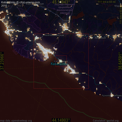
Analysis of Kabardinka night lights 2016
Square area 10x10 km:
 1.52%
1.52%90-99
1.36%80-89
2.58%70-79
0.61%60-69
2.12%50-59
0.45%40-49
2.27%30-39
1.21%20-29
1.06%10-19
12.58%0-9
74.24%Square area 50x50 km:
1.99%90-99
2.51%80-89
0.72%70-79
0.9%60-69
0.76%50-59
1.04%40-49
0.82%30-39
1.27%20-29
3.32%10-19
8.63%0-9
78.04%Clear (daylight) street map image can be seen on geolist.org.
Map coordinates:
45° 8' 57.9" North, 37° 14' 22.8" East
44° 39' 5" North, 37° 56' 34" East
44° 8' 56.5" North, 38° 38' 45.3" East
Some cities around Kabardinka sort by population:
• Novorossiysk
16.1 km =10 mi,  300°
300°
• Krymsk
31.1 km =19.3 mi,  7°
7°
• Gelendzhik
15 km =9.3 mi,  131°
131°
• Abinsk
29.4 km =18.3 mi,  35°
35°
• Myskhako
14 km =8.7 mi,  273°
273°
• Gayduk
24.2 km =15 mi,  307°
307°
• Verkhnebakanskiy
31.5 km =19.6 mi, 314°
• Divnomorskoye
22.5 km =14 mi,  137°
137°
554668 (p: 7,395)
Sources (retrieved 2019-11-25):
» Earth at Night: Flat Maps 2012, 2016